Reading large tiles from S3 directly with `rasterio`
At SpotR, we make heavy use of rasterdata containing gridded height measurements.
When working in python, the rasterio package is useful. This package is
essentially a more pythonic binding to the GDAl library, as explained in their
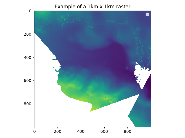
introduction. The file below was obtained from data.gov.uk and shows a 1x1km
patch of height measurements in the UK. The resolution is 1000x1000 pixels,
every pixel represents the (maximum) height of 1x1m. The lighter dots along the
top of the image are houses, there are some ragged parts where there is no data.
In the middle there is a depression, could be a riverbed, and then at the bottom
the terrain is rising a little.
import rasterio
import matplotlib.pyplot as plt
import numpy as np

with rasterio.open("/tmp/sd9863_DSM_1M.tiff") as dataset:
   heights = dataset.read(1)

fn = "images/heights.png"

# replace nodata values with nan
heights[np.where(heights==dataset.nodata)] = np.nan

plt.imshow(heights)
plt.title("Example of a 1km x 1km raster")
plt.tight_layout()
plt.savefig(fn)
fn
Rastertiles, typically GeoTiff files, can become quite large in terms of memory
size. This grid above takes up \~4Mb as an uncompressed GeoTiff file, down from
6.5Mb as a .asc file, which is a simple text-based format. There are a couple
of interesting compression techniques like DEFLATE and LZW that can bring the
size of the data down further. It is possible to convert rasters with
rasterio, but the gdal_translate utility is the tool for the job.
gdal_translate /tmp/sd9863_DSM_1M.asc /tmp/sd9863_DSM_1M.tiff > /dev/null
gdal_translate /tmp/sd9863_DSM_1M.asc /tmp/sd9863_DSM_1M_lzw.tiff -co COMPRESS=LZW > /dev/null
gdal_translate /tmp/sd9863_DSM_1M.asc /tmp/sd9863_DSM_1M_def.tiff -co COMPRESS=DEFLATE > /dev/null
gdal_translate /tmp/sd9863_DSM_1M.asc /tmp/sd9863_DSM_1M_def_pred.tiff -co COMPRESS=DEFLATE -co PREDICTOR=2 > /dev/null
ls -lha /tmp/sd*
-rw-rw-r-- 1 gijs gijs 6,5M jun 13  2018 /tmp/sd9863_DSM_1M.asc
-rw-rw-r-- 1 gijs gijs 1,1M mei  9 09:11 /tmp/sd9863_DSM_1M_def_pred.tiff
-rw-rw-r-- 1 gijs gijs 1,5M mei  9 09:11 /tmp/sd9863_DSM_1M_def.tiff
-rw-rw-r-- 1 gijs gijs 1,8M mei  9 09:11 /tmp/sd9863_DSM_1M_lzw.tiff
-rw-rw-r-- 1 gijs gijs 3,9M mei  9 09:11 /tmp/sd9863_DSM_1M.tiff
Interestingly, all compression techniques available in GDAL are lossless.
There are JPEG based compression systems, but they can only be applied to 8bit
unsigned data, in other words, images, and these height measurements which are
organized as floating point numbers cannot be stored using JPEG compression. I
can definitely think of some usecases where some distortion of these
measurements is fine, as long as it's bounded somehow, but I haven't come across
examples of a lossy compression for rasters of floating points.
Partial reads
Compression can save us almost an order of magnitude, but to store this data at our scale, things still add up. I live in the Netherlands which has an area of 41,543 km2. That's 40k+ tiles at 1Mb+ each, 50Gb in total. Perfect to save on cloud storage such as S3.
aws s3 ls s3://heights-tiles/tiles/sd980
2022-04-29  23:08:55  2903641  sd9800_DSM_1M.tiff
2022-04-29  23:08:54  2871755  sd9801_DSM_1M.tiff
2022-04-29  23:08:54  2938302  sd9802_DSM_1M.tiff
2022-04-29  23:08:55  2719476  sd9803_DSM_1M.tiff
2022-04-29  23:08:55  2643684  sd9804_DSM_1M.tiff
2022-04-29  23:08:55  2533681  sd9805_DSM_1M.tiff
2022-04-29  23:08:55  2715498  sd9806_DSM_1M.tiff
2022-04-29  23:08:55  2818095  sd9807_DSM_1M.tiff
2022-04-29  23:08:55  2755601  sd9808_DSM_1M.tiff
2022-04-29  23:08:56   468739  sd9809_DSM_1M.tiff
When doing a calculation, we're typically not interested in the whole of the tile. For example, we only want to know the height of a single pixel in the raster file. It is possible to avoid downloading the whole file, this operation can be done using a partial read. This is possible because S3 allows random-access reads, and GDAL supports reading over a network with virtual file systems.
Depending on how large your tiles are, this can make a big difference. Let's benchmark this.
import rasterio
from rasterio.windows import Window

with rasterio.open("s3://heights-tiles/tiles/sd9800_DSM_1M.tiff") as raster:
  dt = raster.read(1, window=Window(500, 500, 501, 501))
time python src/read_raster_window.py
real    0m17,300s
user    0m3,026s
sys     0m1,038s
Wait a minute .. 17 seconds is still a long time. It turns out that GDAL will
scan the whole folder for other files before opening a file. This is interesting
behaviour that makes sense when geodata files are often accompanied by other
files that include information about transformation, possibly some indexes and
more. We can disable this behaviour by setting an environment value.
time GDAL_DISABLE_READDIR_ON_OPEN=YES python src/read_raster_window.py
real    0m1,230s
user    0m0,400s
sys     0m0,948s